

Lat Long Calc

توضیحات Lat Long Calc
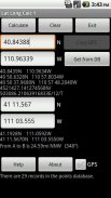
Lat Long Calc is a GPS tool that converts latitude/longitude coordinates to different formats and calculates distance and direction between two points. This is the free version. For more features look for Lat Long Calc Pro.
** If you find a bug, e-mail me and I will fix it. **
Of particular use in Search and Rescue (SAR) & GIS where conversion between different formats is needed.
Also useful in Geocaching, surveying or anything where you need to convert coordinates between formats.
Please contact me at cruthuservices@gmail.com for help before rating poorly.
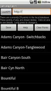
Supports DD.DDD, DD MM.MMM, DD MM SS.SSS, UTM and Maidenhead Locator. Can load points from a GPX and/or save points in local DB for later use.
Maidenhead Locator (4 or 6 digit) is useful for Ham (Amateur) Radio contacts or contesting.
Can use internal GPS to get current position which can also be saved to a local DB.
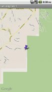
Includes mapping support. See your positions on a map. Options to use internal rendered Google Maps or external map provider such as Google Maps, or other map programs.
Long click on coordinate results to show map. Read help for more details.
Does not share any information. Internet access is for downloading your specified GPX file. GPS is only used if you select it.
Now has batter support for small screen devices.
Note: Mapping support requires Google Maps be installed.
عرض بلند کالک یک ابزار GPS که تبدیل طول / عرض مختصات به فرمت های مختلف و محاسبه فاصله و جهت بین دو نقطه است. این نسخه رایگان است. برای ویژگی های بیشتر برای لات بلند کالک نگاه طرفدار.
** اگر شما پیدا کردن یک اشکال، پست الکترونیکی من و من آن را تعمیر خواهد کرد. **
از استفاده خاص در جستجو و نجات (SAR) و GIS که در آن تبدیل بین فرمت های مختلف مورد نیاز است.
همچنین در محاسبه مساحت مفید، نقشه برداری و یا هر چیزی که در آن شما نیاز به تبدیل مختصات بین فرمت های.
لطفا به من در cruthuservices@gmail.com برای کمک قبل از امتیاز ضعیف تماس بگیرید.
پشتیبانی از DD.DDD، DD MM.MMM، DD MM SS.SSS، UTM و پرده بکارت یاب. می توانید امتیاز از GPX بار و / یا ذخیره نقاط در DB محلی برای استفاده های بعدی.
پرده بکارت یاب (4 یا 6 رقمی) برای مخاطبین (آماتور) رادیو ژامبون یا رقابت مفید است.
می توانید GPS داخلی برای به دست آوردن موقعیت فعلی که همچنین می تواند به یک DB محلی ذخیره شود استفاده کنید.
شامل پشتیبانی نقشه برداری. موقعیت خود را بر روی نقشه مشاهده کنید. گزینه هایی برای استفاده داخلی ارائه نقشه های گوگل یا ارائه دهنده نقشه های خارجی مانند نقشه های گوگل، و یا دیگر برنامه نقشه.
طولانی با کلیک بر هماهنگی نتیجه ای برای نمایش بر روی نقشه. خوانده شده کمک برای جزئیات بیشتر.
آیا هر گونه اطلاعات به اشتراک بگذارند. دسترسی به اینترنت برای دانلود فایل GPX مشخص خود را. GPS استفاده شده است تنها اگر شما آن را انتخاب کنید.
در حال حاضر پشتیبانی خمیر برای دستگاه های صفحه نمایش کوچک است.
توجه: پشتیبانی نقشه برداری نیاز به نقشه های گوگل نصب شده است.


